Sânnicolau Mare night lights from space
Night Light of Sânnicolau Mare (Timiş) from space (Romania) Src. Average luminocity for 10x10km area is 8.0412% and for 50x50km: 2.2565%.
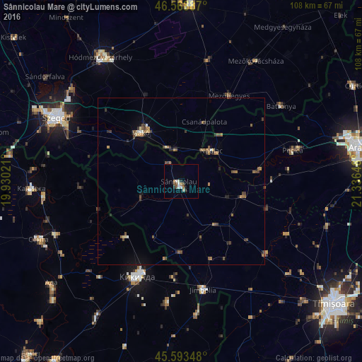
Analysis of Sânnicolau Mare night lights 2016
Square area 10x10 km:
 1.42%
1.42%90-99
1.85%80-89
0.14%70-79
0.14%60-69
1.56%50-59
0.85%40-49
1.42%30-39
0.57%20-29
1.14%10-19
0.57%0-9
90.34%Square area 50x50 km:
0.11%90-99
0.17%80-89
0.17%70-79
0.26%60-69
0.5%50-59
0.49%40-49
0.56%30-39
0.48%20-29
0.37%10-19
0.45%0-9
96.44%Clear (daylight) street map image can be seen on geolist.org.
Map coordinates:
46° 34' 7.9" North, 19° 55' 48.8" East
46° 4' 60" North, 20° 37' 60" East
45° 35' 36.5" North, 21° 20' 11.3" East
Some cities around Sânnicolau Mare sort by population:
• Makó, HU
18.8 km =11.7 mi,  322°
322°
• Lovrin
16.6 km =10.3 mi,  140°
140°
• Nădlac
12.9 km =8 mi,  44°
44°
• Mokrin, RS
23.9 km =14.9 mi,  225°
225°
• Periam
18.4 km =11.4 mi,  101°
101°
• Variaş
25.5 km =15.8 mi,  106°
106°
• Sânpetru Mare
14.9 km =9.3 mi, 106°
• Dudeştii Vechi
12.2 km =7.6 mi,  252°
252°
666973 (p: 12,888)
Sources (retrieved 2019-11-25):
» Earth at Night: Flat Maps 2012, 2016