Periş night lights from space
Night Light of Periş (Ilfov) from space (Romania) Src. Average luminocity for 10x10km area is 5.7409% and for 50x50km: 14.3921%.
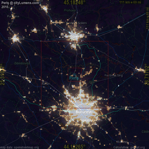
Analysis of Periş night lights 2016
Square area 10x10 km:
100  0%
0%
90-99 0%
80-89 0%
70-79 0%
60-69 1.82%
50-59 1.82%
40-49 0%
30-39 1.52%
20-29 2.27%
10-19 6.82%
0-9 85.76%
0%90-99
0%80-89
0%70-79
0%60-69
1.82%50-59
1.82%40-49
0%30-39
1.52%20-29
2.27%10-19
6.82%0-9
85.76%Square area 50x50 km:
100 2.55%
90-99 2.94%
80-89 1.32%
70-79 1.46%
60-69 1.92%
50-59 1.58%
40-49 2.39%
30-39 2.6%
20-29 4.01%
10-19 7.27%
0-9 71.97%
2.55%90-99
2.94%80-89
1.32%70-79
1.46%60-69
1.92%50-59
1.58%40-49
2.39%30-39
2.6%20-29
4.01%10-19
7.27%0-9
71.97%Clear (daylight) street map image can be seen on geolist.org.
Map coordinates:
45° 10' 56.9" North, 25° 18' 38.8" East
44° 41' 5" North, 26° 0' 50" East
44° 10' 57.5" North, 26° 43' 1.3" East
Some cities around Periş sort by population:
• Buftea
14.6 km =9.1 mi,  200°
200°
• Otopeni
15.6 km =9.7 mi,  164°
164°
• Cojasca
13.4 km =8.3 mi,  285°
285°
• Baloteşti
11.1 km =6.9 mi,  132°
132°
• Crevedia
11.4 km =7.1 mi,  214°
214°
• Snagov
13.5 km =8.4 mi,  82°
82°
• Gorgota
12.3 km =7.6 mi,  26°
26°
• Şirna
13.8 km =8.6 mi,  338°
338°
671118 (p: 7,235)
Sources (retrieved 2019-11-25):
» Earth at Night: Flat Maps 2012, 2016