Brăneşti night lights from space
Night Light of Brăneşti (Ilfov) from space (Romania) Src. Average luminocity for 10x10km area is 16.5952% and for 50x50km: 19.9798%.
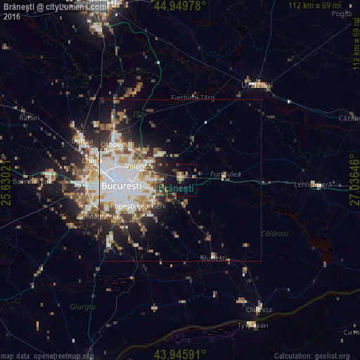
Analysis of Brăneşti night lights 2016
Square area 10x10 km:
 0%
0%90-99
0%80-89
1.27%70-79
3.49%60-69
3.02%50-59
3.17%40-49
3.17%30-39
2.7%20-29
4.29%10-19
27.3%0-9
51.59%Square area 50x50 km:
5.61%90-99
4.38%80-89
1.73%70-79
1.97%60-69
2.41%50-59
1.96%40-49
2.71%30-39
2.25%20-29
4.24%10-19
6.44%0-9
66.31%Clear (daylight) street map image can be seen on geolist.org.
Map coordinates:
44° 56' 59.2" North, 25° 37' 48.8" East
44° 27' 0" North, 26° 19' 60" East
43° 56' 45.3" North, 27° 2' 11.3" East
Some cities around Brăneşti sort by population:
• Sector 3
13.4 km =8.3 mi,  257°
257°
• Voluntari
13.4 km =8.3 mi,  289°
289°
• Pantelimon
10.6 km =6.6 mi,  270°
270°
• Cernica
5.4 km =3.4 mi,  226°
226°
• Glina
9.9 km =6.2 mi,  221°
221°
• Afumaţi
9.1 km =5.7 mi,  324°
324°
• Dobroeşti
11.9 km =7.4 mi, 270°
• Fundeni
7.5 km =4.7 mi,  169°
169°
683886 (p: 8,645)
Sources (retrieved 2019-11-25):
» Earth at Night: Flat Maps 2012, 2016