Băile Herculane night lights from space
Night Light of Băile Herculane (Caraş-Severin) from space (Romania) Src. Average luminocity for 10x10km area is 1.2968% and for 50x50km: 0.5292%.
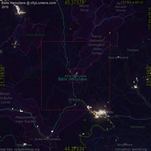
Analysis of Băile Herculane night lights 2016
Square area 10x10 km:
 0%
0%90-99
0%80-89
0%70-79
0.63%60-69
0%50-59
0%40-49
0%30-39
0.32%20-29
1.43%10-19
0.79%0-9
96.83%Square area 50x50 km:
0.04%90-99
0.06%80-89
0.04%70-79
0.04%60-69
0.02%50-59
0.02%40-49
0.07%30-39
0.06%20-29
0.14%10-19
0.9%0-9
98.61%Clear (daylight) street map image can be seen on geolist.org.
Map coordinates:
45° 22' 32.8" North, 21° 42' 33.8" East
44° 52' 47" North, 22° 24' 45" East
44° 22' 45.6" North, 23° 6' 56.3" East
Some cities around Băile Herculane sort by population:
• Drobeta-Turnu Severin
33.9 km =21.1 mi,  145°
145°
• Motru
44.9 km =27.9 mi,  100°
100°
• Orşova
17.5 km =10.9 mi,  184°
184°
• Şimian
37.6 km =23.4 mi,  141°
141°
• Anina
49 km =30.4 mi,  296°
296°
• Tismana
47.5 km =29.5 mi,  66°
66°
• Mătăsari
53 km =32.9 mi,  93°
93°
• Padeş
37.6 km =23.4 mi, 66°
685796 (p: 6,022)
Sources (retrieved 2019-11-25):
» Earth at Night: Flat Maps 2012, 2016