Dukhān night lights from space
Night Light of Dukhān (Al-Shahaniya) from space (Qatar) Src. Average luminocity for 10x10km area is 69.8373% and for 50x50km: 12.8509%.
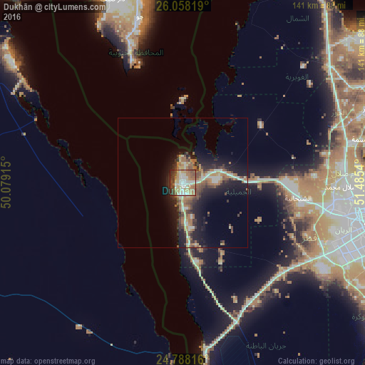
Analysis of Dukhān night lights 2016
Square area 10x10 km:
 8.73%
8.73%90-99
16.47%80-89
16.27%70-79
10.32%60-69
14.48%50-59
10.71%40-49
9.72%30-39
9.92%20-29
2.98%10-19
0.4%0-9
0%Square area 50x50 km:
1.25%90-99
1.74%80-89
1.73%70-79
1.38%60-69
3.02%50-59
2.02%40-49
2.13%30-39
2.19%20-29
3.51%10-19
9.08%0-9
71.95%Clear (daylight) street map image can be seen on geolist.org.
Map coordinates:
26° 3' 29.5" North, 50° 4' 44.9" East
25° 25' 29.5" North, 50° 46' 56.2" East
24° 47' 17.4" North, 51° 29' 7.4" East
Some cities around Dukhān sort by population:
• Doha
76.8 km =47.7 mi,  101°
101°
• Ar Rayyān
66.2 km =41.1 mi, 102°
• Dār Kulayb, BH
76.8 km =47.7 mi,  338°
338°
• Umm Şalāl Muḩammad
62.7 km =39 mi,  90°
90°
• Al Khawr
78.1 km =48.5 mi,  68°
68°
• Ash Shīḩānīyah
44.6 km =27.7 mi, 97°
• Az̧ Z̧a‘āyin
72.3 km =44.9 mi,  76°
76°
• Umm Şalāl ‘Alī
62 km =38.5 mi, 85°
289813 (p: 7,250)
Sources (retrieved 2019-11-25):
» Earth at Night: Flat Maps 2012, 2016