Alijó night lights from space
Night Light of Alijó (Vila Real) from space (Portugal) Src. Average luminocity for 10x10km area is 8.2484% and for 50x50km: 7.3736%.
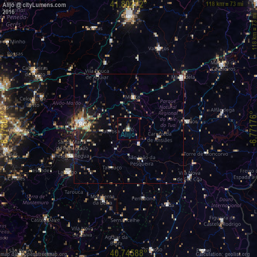
Analysis of Alijó night lights 2016
Square area 10x10 km:
 0.65%
0.65%90-99
0.65%80-89
1.46%70-79
1.14%60-69
0%50-59
1.95%40-49
0.65%30-39
2.27%20-29
0.65%10-19
0.65%0-9
89.94%Square area 50x50 km:
0.48%90-99
1.14%80-89
1.01%70-79
0.51%60-69
0.96%50-59
1.34%40-49
1.05%30-39
1.14%20-29
2.43%10-19
3.85%0-9
86.09%Clear (daylight) street map image can be seen on geolist.org.
Map coordinates:
41° 48' 9.8" North, 8° 10' 40.8" West
41° 16' 35.2" North, 7° 28' 29.6" West
40° 44' 45.2" North, 6° 46' 18.3" West
Some cities around Alijó sort by population:
• Custoias
23 km =14.3 mi,  145°
145°
• Vila Real
22.7 km =14.1 mi,  276°
276°
• São João da Pesqueira
15.4 km =9.6 mi,  157°
157°
• Carrazeda de Anciães
14.5 km =9 mi,  105°
105°
• Sabrosa
8.5 km =5.3 mi,  262°
262°
• Tabuaço
19.4 km =12.1 mi,  203°
203°
• Vilela
12.2 km =7.6 mi,  242°
242°
• Peso da Régua
29.1 km =18.1 mi, 244°
2743067 (p: 11,942)
Sources (retrieved 2019-11-25):
» Earth at Night: Flat Maps 2012, 2016