Vila Nova da Telha night lights from space
Night Light of Vila Nova da Telha (Porto) from space (Portugal) Src. Average luminocity for 10x10km area is 72.5649% and for 50x50km: 41.9443%.
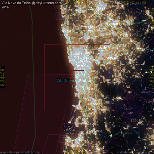
Analysis of Vila Nova da Telha night lights 2016
Square area 10x10 km:
 41.07%
90-99
19.48%80-89
3.41%70-79
0.32%60-69
0.65%50-59
1.3%40-49
1.46%30-39
8.6%20-29
11.85%10-19
10.88%0-9
0.97%Square area 50x50 km:
13.39%90-99
9.36%80-89
4.73%70-79
6.1%60-69
6.02%50-59
3.79%40-49
3.38%30-39
3.76%20-29
4.66%10-19
6.02%0-9
38.77%Clear (daylight) street map image can be seen on geolist.org.
Map coordinates:
41° 35' 58.7" North, 9° 20' 40.5" West
41° 4' 18.1" North, 8° 38' 29.3" West
40° 32' 22.2" North, 7° 56' 18" West
Some cities around Vila Nova da Telha sort by population:
• Vilar do Paraíso
2.6 km =1.6 mi,  40°
40°
• Arcozelo
1.4 km =0.9 mi,  143°
143°
• Canelas
3.7 km =2.3 mi,  69°
69°
• Azenha
1.5 km =0.9 mi, 69°
• São Félix da Marinha
4.3 km =2.7 mi,  158°
158°
• Gulpilhares
1.8 km =1.1 mi, 44°
• Serzedo
3.1 km =1.9 mi, 137°
• Perozinho
4.8 km =3 mi,  98°
98°
2732551 (p: 5,848)
Sources (retrieved 2019-11-25):
» Earth at Night: Flat Maps 2012, 2016