Vale de Cambra night lights from space
Night Light of Vale de Cambra (Aveiro) from space (Portugal) Src. Average luminocity for 10x10km area is 41.4898% and for 50x50km: 32.4497%.
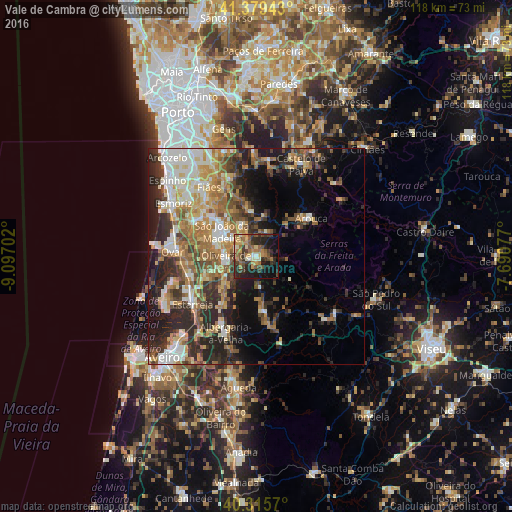
Analysis of Vale de Cambra night lights 2016
Square area 10x10 km:
 1.19%
1.19%90-99
4.42%80-89
5.61%70-79
7.31%60-69
10.54%50-59
8.33%40-49
6.12%30-39
13.1%20-29
17.35%10-19
20.75%0-9
5.27%Square area 50x50 km:
4.08%90-99
6.07%80-89
3.98%70-79
4.94%60-69
6.25%50-59
4.92%40-49
4.13%30-39
5.48%20-29
10.14%10-19
11.02%0-9
38.99%Clear (daylight) street map image can be seen on geolist.org.
Map coordinates:
41° 22' 45.9" North, 9° 5' 49.3" West
40° 50' 58.9" North, 8° 23' 38" West
40° 18' 56.5" North, 7° 41' 26.8" West
Some cities around Vale de Cambra sort by population:
• São João da Madeira
9.9 km =6.2 mi,  305°
305°
• Feira
15.1 km =9.4 mi,  303°
303°
• Oliveira de Azemeis
6.9 km =4.3 mi,  261°
261°
• Cucujães
9.9 km =6.2 mi,  285°
285°
• Arrifana
11.3 km =7 mi, 310°
• Avanca
15.7 km =9.8 mi,  252°
252°
• Branca
11.9 km =7.4 mi,  218°
218°
• São Roque
7 km =4.3 mi, 290°
2733153 (p: 7,649)
Sources (retrieved 2019-11-25):
» Earth at Night: Flat Maps 2012, 2016