Santo Tirso night lights from space
Night Light of Santo Tirso (Porto) from space (Portugal) Src. Average luminocity for 10x10km area is 65.881% and for 50x50km: 66.2884%.
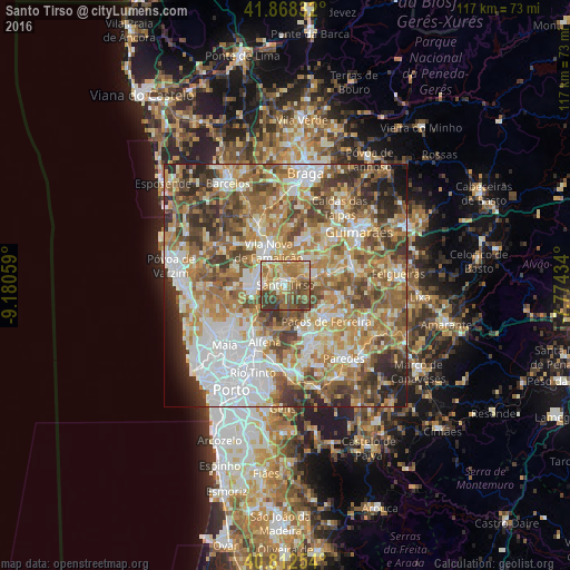
Analysis of Santo Tirso night lights 2016
Square area 10x10 km:
 3.23%
3.23%90-99
11.9%80-89
10.88%70-79
11.73%60-69
25%50-59
15.31%40-49
11.73%30-39
10.2%20-29
0%10-19
0%0-9
0%Square area 50x50 km:
13.61%90-99
13.62%80-89
8.74%70-79
11.01%60-69
13.8%50-59
11.55%40-49
9.48%30-39
7.89%20-29
6.11%10-19
2.55%0-9
1.64%Clear (daylight) street map image can be seen on geolist.org.
Map coordinates:
41° 52' 6" North, 9° 10' 50.1" West
41° 20' 33.3" North, 8° 28' 38.9" West
40° 48' 45.1" North, 7° 46' 27.6" West
Some cities around Santo Tirso sort by population:
• Bougado
6.2 km =3.9 mi,  267°
267°
• Trofa
6.9 km =4.3 mi, 265°
• Calendário
8.1 km =5 mi,  327°
327°
• Ribeirão
7.8 km =4.8 mi,  285°
285°
• Aves
6.4 km =4 mi,  61°
61°
• Ferreiros
6.1 km =3.8 mi,  277°
277°
• Negrelos
6.4 km =4 mi,  83°
83°
• São Miguel do Couto
1.8 km =1.1 mi,  132°
132°
2734570 (p: 14,021)
Sources (retrieved 2019-11-25):
» Earth at Night: Flat Maps 2012, 2016