Santo André night lights from space
Night Light of Santo André (Portalegre) from space (Portugal) Src. Average luminocity for 10x10km area is 0.3425% and for 50x50km: 2.1737%.
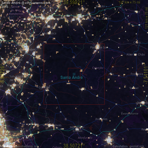
Analysis of Santo André night lights 2016
Square area 10x10 km:
 0%
0%90-99
0%80-89
0%70-79
0.16%60-69
0.16%50-59
0%40-49
0%30-39
0%20-29
0%10-19
0%0-9
99.68%Square area 50x50 km:
0.13%90-99
0.3%80-89
0.35%70-79
0.4%60-69
0.39%50-59
0.3%40-49
0.22%30-39
0.24%20-29
0.41%10-19
0.76%0-9
96.49%Clear (daylight) street map image can be seen on geolist.org.
Map coordinates:
39° 35' 57.2" North, 8° 56' 50.1" West
39° 3' 19.2" North, 8° 14' 38.9" West
38° 30' 26" North, 7° 32' 27.6" West
Some cities around Santo André sort by population:
• Santarém
42.7 km =26.5 mi,  297°
297°
• Montemor-o-Novo
45.3 km =28.1 mi,  176°
176°
• Almeirim
37.1 km =23.1 mi, 297°
• Ponte de Sôr
29.6 km =18.4 mi,  43°
43°
• Coruche
26.5 km =16.5 mi,  246°
246°
• Alpiarça
36.8 km =22.9 mi,  307°
307°
• Fazendas de Almeirim
31.1 km =19.3 mi, 295°
• Marinhais
39.6 km =24.6 mi,  268°
268°
2263438 (p: 11,213)
Sources (retrieved 2019-11-25):
» Earth at Night: Flat Maps 2012, 2016