Coruche night lights from space
Night Light of Coruche (Santarém) from space (Portugal) Src. Average luminocity for 10x10km area is 12.0698% and for 50x50km: 6.1345%.
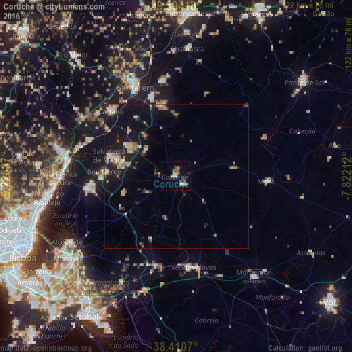
Analysis of Coruche night lights 2016
Square area 10x10 km:
 0.65%
0.65%90-99
1.79%80-89
0.65%70-79
3.08%60-69
1.95%50-59
2.44%40-49
0.65%30-39
0.49%20-29
2.6%10-19
4.06%0-9
81.66%Square area 50x50 km:
0.15%90-99
0.81%80-89
1.16%70-79
0.84%60-69
0.81%50-59
0.79%40-49
0.63%30-39
0.73%20-29
1.75%10-19
6.21%0-9
86.12%Clear (daylight) street map image can be seen on geolist.org.
Map coordinates:
39° 30' 15" North, 9° 13' 42.1" West
38° 57' 34.4" North, 8° 31' 30.9" West
38° 24' 38.5" North, 7° 49' 19.6" West
Some cities around Coruche sort by population:
• Samora Correia
30.1 km =18.7 mi,  265°
265°
• Almeirim
29 km =18 mi,  342°
342°
• Santo André
26.5 km =16.5 mi,  66°
66°
• Cartaxo
31.8 km =19.8 mi,  314°
314°
• Benavente
24.5 km =15.2 mi,  275°
275°
• Fazendas de Almeirim
24.3 km =15.1 mi,  351°
351°
• Marinhais
18.1 km =11.2 mi,  302°
302°
• Salvaterra de Magos
24.4 km =15.2 mi,  288°
288°
2268946 (p: 8,776)
Sources (retrieved 2019-11-25):
» Earth at Night: Flat Maps 2012, 2016