Penafiel night lights from space
Night Light of Penafiel (Porto) from space (Portugal) Src. Average luminocity for 10x10km area is 67.7403% and for 50x50km: 49.5023%.
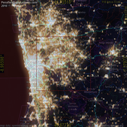
Analysis of Penafiel night lights 2016
Square area 10x10 km:
 7.63%
7.63%90-99
14.45%80-89
9.42%70-79
19.81%60-69
16.56%50-59
9.09%40-49
7.14%30-39
8.44%20-29
7.47%10-19
0%0-9
0%Square area 50x50 km:
7.04%90-99
9.3%80-89
6.96%70-79
8.96%60-69
10.44%50-59
8.67%40-49
7.7%30-39
6.6%20-29
7.88%10-19
9%0-9
17.44%Clear (daylight) street map image can be seen on geolist.org.
Map coordinates:
41° 44' 6.6" North, 8° 59' 9.5" West
41° 12' 30.1" North, 8° 16' 58.3" West
40° 40' 38.1" North, 7° 34' 47" West
Some cities around Penafiel sort by population:
• Paredes
4.1 km =2.5 mi,  264°
264°
• Perafita
3.7 km =2.3 mi,  140°
140°
• Rebordosa
10.5 km =6.5 mi,  279°
279°
• Lordelo
10.5 km =6.5 mi,  286°
286°
• Madalena
4.4 km =2.7 mi, 281°
• Castelões de Cepeda
4.4 km =2.7 mi, 261°
• Freamunde
9.9 km =6.2 mi,  333°
333°
• Paços de Ferreira
10.9 km =6.8 mi,  314°
314°
2736469 (p: 8,065)
Sources (retrieved 2019-11-25):
» Earth at Night: Flat Maps 2012, 2016