Buarcos night lights from space
Night Light of Buarcos (Coimbra) from space (Portugal) Src. Average luminocity for 10x10km area is 34.4708% and for 50x50km: 9.7517%.
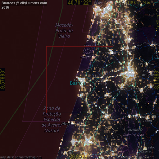
Analysis of Buarcos night lights 2016
Square area 10x10 km:
 8.44%
8.44%90-99
8.77%80-89
1.14%70-79
3.73%60-69
1.3%50-59
2.76%40-49
1.46%30-39
5.19%20-29
15.26%10-19
27.92%0-9
24.03%Square area 50x50 km:
0.73%90-99
1.23%80-89
0.73%70-79
0.9%60-69
1.15%50-59
1.4%40-49
1.34%30-39
1.83%20-29
3.49%10-19
10.82%0-9
76.39%Clear (daylight) street map image can be seen on geolist.org.
Map coordinates:
40° 42' 4.4" North, 9° 34' 47.7" West
40° 9' 57.7" North, 8° 52' 36.5" West
39° 37' 35.8" North, 8° 10' 25.2" West
Some cities around Buarcos sort by population:
• Figueira da Foz
2.1 km =1.3 mi,  142°
142°
• Condeixa-a-Nova
32.7 km =20.3 mi,  100°
100°
• Tavarede
2.6 km =1.6 mi,  87°
87°
• Soure
24.4 km =15.2 mi,  118°
118°
• Mira
31.5 km =19.6 mi,  22°
22°
• Cantanhede
31.3 km =19.4 mi,  50°
50°
• Arazede
23.4 km =14.5 mi,  55°
55°
• Louriçal
21.6 km =13.4 mi,  146°
146°
2741961 (p: 7,865)
Sources (retrieved 2019-11-25):
» Earth at Night: Flat Maps 2012, 2016