Costa de Caparica night lights from space
Night Light of Costa de Caparica (District of Setúbal) from space (Portugal) Src. Average luminocity for 10x10km area is 56.4659% and for 50x50km: 43.1259%.
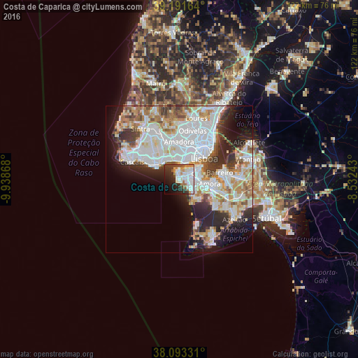
Analysis of Costa de Caparica night lights 2016
Square area 10x10 km:
 19.97%
90-99
13.31%80-89
3.73%70-79
5.52%60-69
5.19%50-59
4.06%40-49
4.38%30-39
9.25%20-29
14.29%10-19
11.85%0-9
8.44%Square area 50x50 km:
14.57%90-99
11.19%80-89
3.68%70-79
4.33%60-69
4.93%50-59
3.49%40-49
3.21%30-39
4.27%20-29
7.32%10-19
8.55%0-9
34.45%Clear (daylight) street map image can be seen on geolist.org.
Map coordinates:
39° 11' 29.9" North, 9° 56' 19.2" West
38° 38' 40.5" North, 9° 14' 8" West
38° 5' 35.9" North, 8° 31' 56.7" West
Some cities around Costa de Caparica sort by population:
• Charneca de Caparica
4.5 km =2.8 mi,  126°
126°
• Caparica
3.6 km =2.2 mi,  57°
57°
• Laranjeira
7.2 km =4.5 mi,  79°
79°
• Piedade
7.3 km =4.5 mi,  67°
67°
• Algés
6.5 km =4 mi,  4°
4°
• Sobreda
4 km =2.5 mi, 81°
• Pragal
6.6 km =4.1 mi, 59°
• Trafaria
3.1 km =1.9 mi, 4°
2268916 (p: 14,231)
Sources (retrieved 2019-11-25):
» Earth at Night: Flat Maps 2012, 2016