Benavente night lights from space
Night Light of Benavente (Santarém) from space (Portugal) Src. Average luminocity for 10x10km area is 32.9253% and for 50x50km: 19.061%.
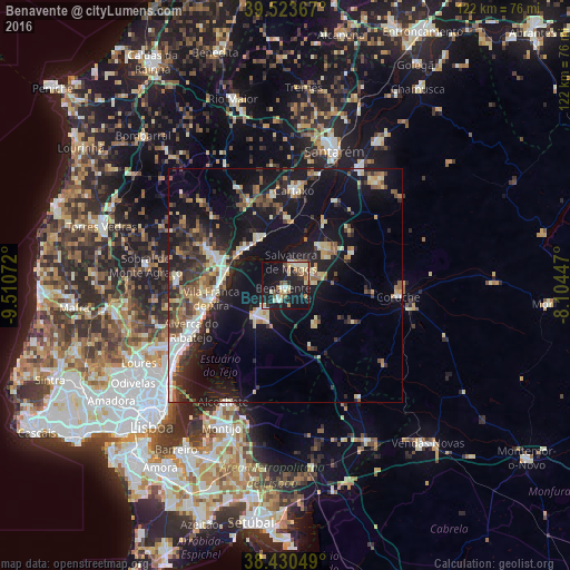
Analysis of Benavente night lights 2016
Square area 10x10 km:
 1.62%
1.62%90-99
7.47%80-89
6.01%70-79
3.73%60-69
4.38%50-59
5.03%40-49
1.79%30-39
2.76%20-29
8.6%10-19
43.99%0-9
14.61%Square area 50x50 km:
1.96%90-99
3.11%80-89
2.34%70-79
1.81%60-69
2.51%50-59
2.69%40-49
2.56%30-39
3.49%20-29
5.54%10-19
18.79%0-9
55.19%Clear (daylight) street map image can be seen on geolist.org.
Map coordinates:
39° 31' 25.2" North, 9° 30' 38.6" West
38° 58' 45.1" North, 8° 48' 27.3" West
38° 25' 49.8" North, 8° 6' 16.1" West
Some cities around Benavente sort by population:
• Vila Franca de Xira
16 km =9.9 mi,  260°
260°
• Samora Correia
7.3 km =4.5 mi,  229°
229°
• Carregado
15.4 km =9.6 mi,  288°
288°
• Castanheira do Ribatejo
14.4 km =8.9 mi,  276°
276°
• Alhandra
18.3 km =11.4 mi,  251°
251°
• Azambuja
11.4 km =7.1 mi,  332°
332°
• Marinhais
11.8 km =7.3 mi,  50°
50°
• Salvaterra de Magos
5.5 km =3.4 mi,  12°
12°
2270940 (p: 8,932)
Sources (retrieved 2019-11-25):
» Earth at Night: Flat Maps 2012, 2016