Alcácer do Sal night lights from space
Night Light of Alcácer do Sal (District of Setúbal) from space (Portugal) Src. Average luminocity for 10x10km area is 9.4099% and for 50x50km: 2.5844%.
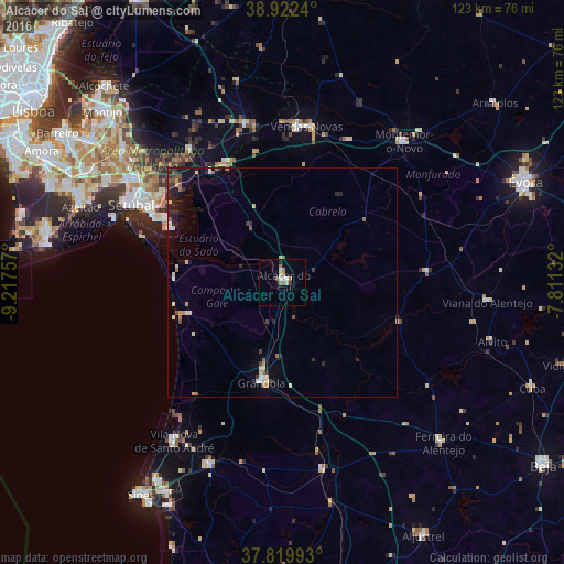
Analysis of Alcácer do Sal night lights 2016
Square area 10x10 km:
 0.68%
0.68%90-99
1.53%80-89
1.87%70-79
0.68%60-69
2.72%50-59
0.68%40-49
0.68%30-39
0.68%20-29
0.68%10-19
0%0-9
89.8%Square area 50x50 km:
0.15%90-99
0.39%80-89
0.43%70-79
0.31%60-69
0.32%50-59
0.35%40-49
0.19%30-39
0.36%20-29
0.74%10-19
1.15%0-9
95.63%Clear (daylight) street map image can be seen on geolist.org.
Map coordinates:
38° 55' 20.6" North, 9° 13' 3.3" West
38° 22' 23.7" North, 8° 30' 52" West
37° 49' 11.7" North, 7° 48' 40.8" West
Some cities around Alcácer do Sal sort by population:
• Setúbal
36.6 km =22.7 mi,  297°
297°
• Palmela
40.1 km =24.9 mi, 302°
• Montemor-o-Novo
40.2 km =25 mi,  40°
40°
• Vendas Novas
34.1 km =21.2 mi,  8°
8°
• Grândola
22.3 km =13.9 mi,  191°
191°
• Santo André
41.9 km =26 mi,  213°
213°
• Quinta do Anjo
43.1 km =26.8 mi, 300°
• Santiago do Cacém
42.6 km =26.5 mi,  201°
201°
2272212 (p: 9,198)
Sources (retrieved 2019-11-25):
» Earth at Night: Flat Maps 2012, 2016