Żnin night lights from space
Night Light of Żnin (Kujawsko-Pomorskie) from space (Poland) Src. Average luminocity for 10x10km area is 5.4255% and for 50x50km: 1.8211%.
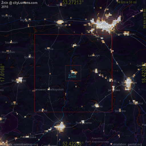
Analysis of Żnin night lights 2016
Square area 10x10 km:
 0.88%
0.88%90-99
0.63%80-89
0.25%70-79
2.27%60-69
0%50-59
1.01%40-49
0.51%30-39
0.51%20-29
0%10-19
0%0-9
93.94%Square area 50x50 km:
0.18%90-99
0.2%80-89
0.18%70-79
0.37%60-69
0.26%50-59
0.15%40-49
0.21%30-39
0.3%20-29
0.27%10-19
1.01%0-9
96.87%Clear (daylight) street map image can be seen on geolist.org.
Map coordinates:
53° 16' 19.7" North, 17° 1' 0.5" East
52° 50' 58.5" North, 17° 43' 11.7" East
52° 25' 22.4" North, 18° 25' 23" East
Some cities around Żnin sort by population:
• Mogilno
26.6 km =16.5 mi,  143°
143°
• Szubin
17.9 km =11.1 mi,  4°
4°
• Janikowo
28.5 km =17.7 mi,  112°
112°
• Trzemeszno
32.8 km =20.4 mi,  167°
167°
• Barcin
15.3 km =9.5 mi,  83°
83°
• Białe Błota
30.3 km =18.8 mi,  25°
25°
• Pakość
25.1 km =15.6 mi,  102°
102°
• Janowiec Wielkopolski
18.7 km =11.6 mi,  236°
236°
3080047 (p: 14,008)
Sources (retrieved 2019-11-25):
» Earth at Night: Flat Maps 2012, 2016