Wieliczka night lights from space
Night Light of Wieliczka (Lesser Poland) from space (Poland) Src. Average luminocity for 10x10km area is 53.923% and for 50x50km: 18.5064%.
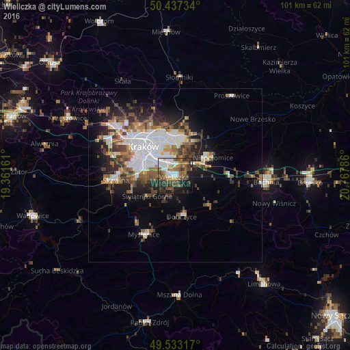
Analysis of Wieliczka night lights 2016
Square area 10x10 km:
 10.36%
90-99
11.34%80-89
2.94%70-79
5.32%60-69
9.38%50-59
11.62%40-49
13.17%30-39
8.96%20-29
11.06%10-19
13.31%0-9
2.52%Square area 50x50 km:
4.31%90-99
3.63%80-89
1.19%70-79
1.43%60-69
2.63%50-59
2.8%40-49
3.05%30-39
3.25%20-29
3.82%10-19
7.2%0-9
66.69%Clear (daylight) street map image can be seen on geolist.org.
Map coordinates:
50° 26' 14.4" North, 19° 21' 41.8" East
49° 59' 14.6" North, 20° 3' 53" East
49° 31' 59.4" North, 20° 46' 4.3" East
Some cities around Wieliczka sort by population:
• Kraków
12.3 km =7.6 mi,  311°
311°
• Bochnia
26.2 km =16.3 mi,  94°
94°
• Skawina
16.9 km =10.5 mi,  265°
265°
• Myślenice
19.3 km =12 mi,  207°
207°
• Niepołomice
12.7 km =7.9 mi,  62°
62°
• Sułkowice
25 km =15.5 mi,  229°
229°
• Dobczyce
11.9 km =7.4 mi,  171°
171°
• Proszowice
27.9 km =17.3 mi,  35°
35°
755889 (p: 18,677)
Sources (retrieved 2019-11-25):
» Earth at Night: Flat Maps 2012, 2016