Szklarska Poręba night lights from space
Night Light of Szklarska Poręba (Lower Silesia) from space (Poland) Src. Average luminocity for 10x10km area is 5.7325% and for 50x50km: 3.6888%.
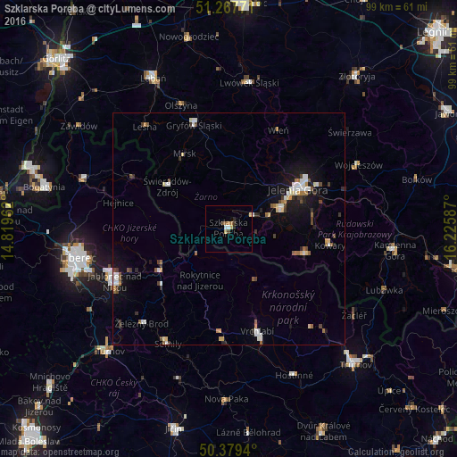
Analysis of Szklarska Poręba night lights 2016
Square area 10x10 km:
 0.42%
0.42%90-99
0.7%80-89
1.68%70-79
0.56%60-69
0.84%50-59
0.84%40-49
0.56%30-39
1.12%20-29
0.56%10-19
0%0-9
92.72%Square area 50x50 km:
0.6%90-99
0.62%80-89
0.42%70-79
0.25%60-69
0.46%50-59
0.39%40-49
0.42%30-39
0.58%20-29
0.39%10-19
2.44%0-9
93.42%Clear (daylight) street map image can be seen on geolist.org.
Map coordinates:
51° 16' 3.8" North, 14° 49' 10.6" East
50° 49' 32.4" North, 15° 31' 21.9" East
50° 22' 45.8" North, 16° 13' 33.1" East
Some cities around Szklarska Poręba sort by population:
• Jelenia Góra
16.7 km =10.4 mi,  60°
60°
• Cieplice Śląskie Zdrój
12.1 km =7.5 mi,  68°
68°
• Vrchlabí, CZ
22.9 km =14.2 mi,  164°
164°
• Kowary
22.3 km =13.9 mi,  99°
99°
• Tanvald, CZ
18.1 km =11.2 mi,  237°
237°
• Gryfów Śląski
23.9 km =14.9 mi,  342°
342°
• Piechowice
6 km =3.7 mi, 63°
• Mysłakowice
18.1 km =11.2 mi,  84°
84°
3083677 (p: 6,970)
Sources (retrieved 2019-11-25):
» Earth at Night: Flat Maps 2012, 2016