Stęszew night lights from space
Night Light of Stęszew (Greater Poland) from space (Poland) Src. Average luminocity for 10x10km area is 8.7816% and for 50x50km: 17.7403%.
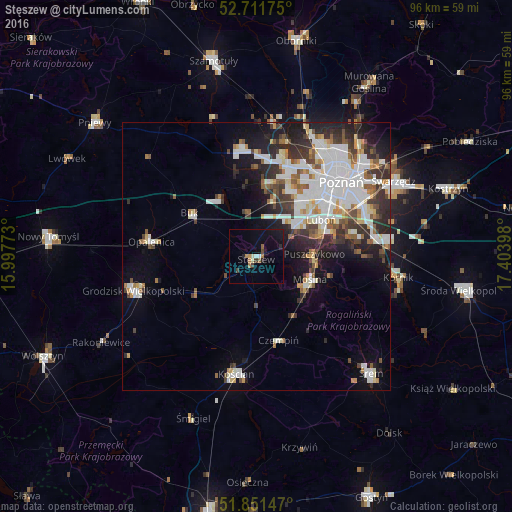
Analysis of Stęszew night lights 2016
Square area 10x10 km:
 0.51%
0.51%90-99
1.14%80-89
0.38%70-79
0.51%60-69
2.15%50-59
0.88%40-49
0.76%30-39
1.26%20-29
1.52%10-19
6.31%0-9
84.6%Square area 50x50 km:
4.63%90-99
4.19%80-89
1.36%70-79
1.41%60-69
1.57%50-59
1.97%40-49
1.74%30-39
2.94%20-29
4.1%10-19
6.8%0-9
69.28%Clear (daylight) street map image can be seen on geolist.org.
Map coordinates:
52° 42' 42.3" North, 15° 59' 51.8" East
52° 17' 1.3" North, 16° 42' 3.1" East
51° 51' 5.3" North, 17° 24' 14.3" East
Some cities around Stęszew sort by population:
• Luboń
14.8 km =9.2 mi,  61°
61°
• Mosina
10.8 km =6.7 mi,  113°
113°
• Puszczykowo
10.1 km =6.3 mi,  88°
88°
• Opalenica
19.8 km =12.3 mi,  278°
278°
• Buk
14.7 km =9.1 mi,  302°
302°
• Plewiska
11.9 km =7.4 mi,  38°
38°
• Komorniki
9.6 km =6 mi,  50°
50°
• Czempiń
16.1 km =10 mi,  164°
164°
3084647 (p: 5,596)
Sources (retrieved 2019-11-25):
» Earth at Night: Flat Maps 2012, 2016