Śmigiel night lights from space
Night Light of Śmigiel (Greater Poland) from space (Poland) Src. Average luminocity for 10x10km area is 1.9722% and for 50x50km: 3.1144%.
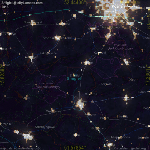
Analysis of Śmigiel night lights 2016
Square area 10x10 km:
 0%
0%90-99
0.63%80-89
0.51%70-79
0.38%60-69
0.51%50-59
0%40-49
0%30-39
0%20-29
0%10-19
0.51%0-9
97.47%Square area 50x50 km:
0.55%90-99
0.53%80-89
0.26%70-79
0.31%60-69
0.43%50-59
0.27%40-49
0.36%30-39
0.31%20-29
0.35%10-19
2.13%0-9
94.51%Clear (daylight) street map image can be seen on geolist.org.
Map coordinates:
52° 26' 38.6" North, 15° 49' 26.1" East
52° 0' 48.2" North, 16° 31' 37.3" East
51° 34' 42.7" North, 17° 13' 48.6" East
Some cities around Śmigiel sort by population:
• Leszno
19.5 km =12.1 mi,  170°
170°
• Kościan
11.8 km =7.3 mi,  44°
44°
• Wschowa
27.1 km =16.8 mi,  212°
212°
• Grodzisk Wielkopolski
26.3 km =16.3 mi,  335°
335°
• Wolsztyn
30.2 km =18.8 mi,  292°
292°
• Mosina
33.8 km =21 mi, 40°
• Stęszew
32.3 km =20.1 mi,  21°
21°
• Czempiń
21.8 km =13.5 mi,  48°
48°
3085391 (p: 5,531)
Sources (retrieved 2019-11-25):
» Earth at Night: Flat Maps 2012, 2016