Kietrz night lights from space
Night Light of Kietrz (Opole Voivodeship) from space (Poland) Src. Average luminocity for 10x10km area is 0.4412% and for 50x50km: 4.816%.
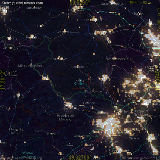
Analysis of Kietrz night lights 2016
Square area 10x10 km:
 0%
0%90-99
0%80-89
0%70-79
0%60-69
0%50-59
0.28%40-49
0.28%30-39
0%20-29
0.42%10-19
0.14%0-9
98.88%Square area 50x50 km:
0.53%90-99
0.79%80-89
0.25%70-79
0.59%60-69
0.61%50-59
0.57%40-49
0.76%30-39
0.94%20-29
1.43%10-19
3.14%0-9
90.4%Clear (daylight) street map image can be seen on geolist.org.
Map coordinates:
50° 31' 46.2" North, 17° 18' 4.3" East
50° 4' 49.5" North, 18° 0' 15.6" East
49° 37' 37.5" North, 18° 42' 26.8" East
Some cities around Kietrz sort by population:
• Opava, CZ
17.4 km =10.8 mi,  204°
204°
• Racibórz
15.4 km =9.6 mi,  85°
85°
• Krnov, CZ
21.5 km =13.4 mi,  272°
272°
• Hlučín, CZ
24.3 km =15.1 mi,  146°
146°
• Głubczyce
18.3 km =11.4 mi,  316°
316°
• Kravaře, CZ
16.5 km =10.3 mi,  179°
179°
• Kuźnia Raciborska
25.6 km =15.9 mi,  58°
58°
• Hradec nad Moravici, CZ
25 km =15.5 mi, 201°
3096240 (p: 6,306)
Sources (retrieved 2019-11-25):
» Earth at Night: Flat Maps 2012, 2016