Szczyrk night lights from space
Night Light of Szczyrk (Silesia) from space (Poland) Src. Average luminocity for 10x10km area is 12.8503% and for 50x50km: 9.3681%.
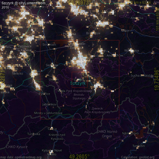
Analysis of Szczyrk night lights 2016
Square area 10x10 km:
 0.27%
0.27%90-99
0.8%80-89
1.47%70-79
0.53%60-69
2.27%50-59
1.6%40-49
3.21%30-39
3.48%20-29
4.28%10-19
17.91%0-9
64.17%Square area 50x50 km:
1.66%90-99
1.55%80-89
0.6%70-79
0.61%60-69
1.03%50-59
1.17%40-49
1.59%30-39
1.87%20-29
2.65%10-19
6.83%0-9
80.44%Clear (daylight) street map image can be seen on geolist.org.
Map coordinates:
50° 10' 11" North, 18° 19' 43.4" East
49° 43' 2.1" North, 19° 1' 54.6" East
49° 15' 37.8" North, 19° 44' 5.9" East
Some cities around Szczyrk sort by population:
• Bielsko-Biala
11.7 km =7.3 mi,  5°
5°
• Żywiec
12.1 km =7.5 mi,  107°
107°
• Ustroń
16.5 km =10.3 mi,  271°
271°
• Wisła
14.2 km =8.8 mi,  241°
241°
• Łodygowice
7.9 km =4.9 mi,  79°
79°
• Jaworze
10.4 km =6.5 mi,  324°
324°
• Wilkowice
6.6 km =4.1 mi,  39°
39°
• Brenna
9.3 km =5.8 mi,  275°
275°
3083752 (p: 5,860)
Sources (retrieved 2019-11-25):
» Earth at Night: Flat Maps 2012, 2016