Kaleke Mandi night lights from space
Night Light of Kaleke Mandi (Punjab) from space (Pakistan) Src. Average luminocity for 10x10km area is 0.4773% and for 50x50km: 3.0822%.
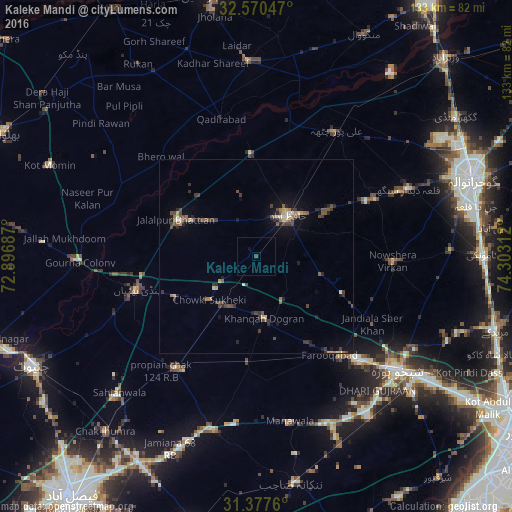
Analysis of Kaleke Mandi night lights 2016
Square area 10x10 km:
 0%
0%90-99
0%80-89
0%70-79
0%60-69
0%50-59
0%40-49
0.35%30-39
0.35%20-29
0%10-19
0.52%0-9
98.78%Square area 50x50 km:
0.09%90-99
0.25%80-89
0.33%70-79
0.25%60-69
0.44%50-59
0.55%40-49
0.98%30-39
0.8%20-29
0.8%10-19
1.46%0-9
94.05%Clear (daylight) street map image can be seen on geolist.org.
Map coordinates:
32° 34' 13.7" North, 72° 53' 48.7" East
31° 58' 33.5" North, 73° 35' 60" East
31° 22' 39.4" North, 74° 18' 11.2" East
Some cities around Kaleke Mandi sort by population:
• Hafizabad
13.4 km =8.3 mi,  38°
38°
• Chuchar-kana Mandi
31.4 km =19.5 mi,  143°
143°
• Sangla Hill
35.4 km =22 mi,  215°
215°
• Naushahra Virkan
35 km =21.7 mi,  92°
92°
• Pindi Bhattian
32 km =19.9 mi,  254°
254°
• Sukheke Mandi
15 km =9.3 mi, 215°
• Khangah Dogran
16 km =9.9 mi,  172°
172°
• Jandiala Sher Khan
34.6 km =21.5 mi,  119°
119°
1175283 (p: 16,361)
Sources (retrieved 2019-11-25):
» Earth at Night: Flat Maps 2012, 2016