Jandiala Sher Khan night lights from space
Night Light of Jandiala Sher Khan (Punjab) from space (Pakistan) Src. Average luminocity for 10x10km area is 2.9359% and for 50x50km: 11.354%.
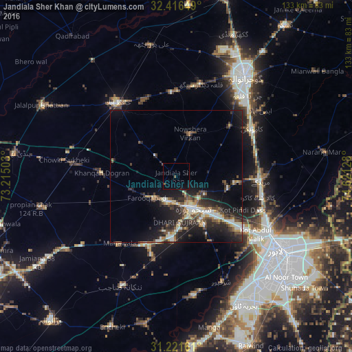
Analysis of Jandiala Sher Khan night lights 2016
Square area 10x10 km:
 0%
0%90-99
0%80-89
0%70-79
0%60-69
0%50-59
1.28%40-49
0.55%30-39
0%20-29
0.73%10-19
2.38%0-9
95.05%Square area 50x50 km:
0.91%90-99
2.31%80-89
1.15%70-79
1.13%60-69
0.82%50-59
1.7%40-49
2.22%30-39
2.11%20-29
4.94%10-19
8.75%0-9
73.97%Clear (daylight) street map image can be seen on geolist.org.
Map coordinates:
32° 24' 59.4" North, 73° 12' 54.1" East
31° 49' 15.5" North, 73° 55' 5.3" East
31° 13' 17.8" North, 74° 37' 16.6" East
Some cities around Jandiala Sher Khan sort by population:
• Shekhupura
13.6 km =8.5 mi,  152°
152°
• Kamoke
33.5 km =20.8 mi,  59°
59°
• Muridke
32.2 km =20 mi,  93°
93°
• Chuchar-kana Mandi
13.7 km =8.5 mi,  234°
234°
• Naushahra Virkan
16.5 km =10.3 mi,  17°
17°
• Khangah Dogran
28 km =17.4 mi,  272°
272°
• Mananwala
33.8 km =21 mi,  219°
219°
• Chak Five Hundred Seventy-five
31.8 km =19.8 mi,  195°
195°
1176206 (p: 10,985)
Sources (retrieved 2019-11-25):
» Earth at Night: Flat Maps 2012, 2016