Santa Ines West night lights from space
Night Light of Santa Ines West (Central Luzon) from space (Philippines) Src. Average luminocity for 10x10km area is 0.0281% and for 50x50km: 4.8226%.
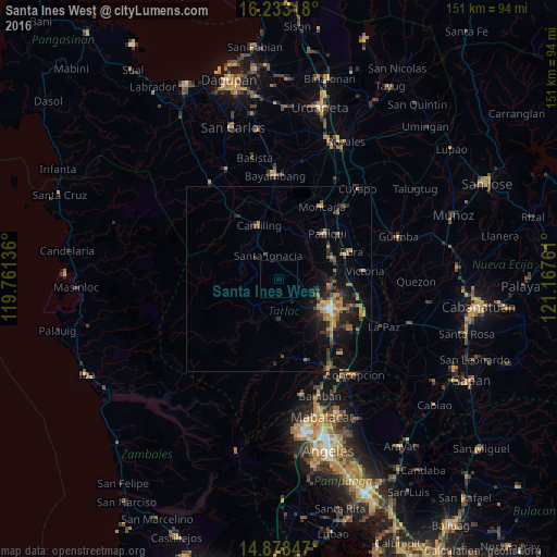
Analysis of Santa Ines West night lights 2016
Square area 10x10 km:
 0%
0%90-99
0%80-89
0%70-79
0%60-69
0%50-59
0%40-49
0%30-39
0%20-29
0%10-19
0%0-9
100%Square area 50x50 km:
0.06%90-99
0.23%80-89
0.42%70-79
1.01%60-69
1.13%50-59
0.67%40-49
0.84%30-39
1.3%20-29
1.56%10-19
3.42%0-9
89.35%Clear (daylight) street map image can be seen on geolist.org.
Map coordinates:
16° 13' 59.4" North, 119° 45' 40.9" East
15° 33' 25" North, 120° 27' 52.1" East
14° 52' 42.5" North, 121° 10' 3.4" East
Some cities around Santa Ines West sort by population:
• Tarlac City
16.7 km =10.4 mi,  120°
120°
• Paniqui
17.6 km =10.9 mi,  44°
44°
• Gerona
15.3 km =9.5 mi,  68°
68°
• Camiling
15.4 km =9.6 mi,  339°
339°
• Sapang
17.5 km =10.9 mi,  21°
21°
• Cut-cut Primero
15.4 km =9.6 mi, 122°
• Mayantoc
11.7 km =7.3 mi,  306°
306°
• Sinilian First
15.2 km =9.4 mi,  357°
357°
1688136 (p: 5,821)
Sources (retrieved 2019-11-25):
» Earth at Night: Flat Maps 2012, 2016