Sapang night lights from space
Night Light of Sapang (Central Luzon) from space (Philippines) Src. Average luminocity for 10x10km area is 1.2662% and for 50x50km: 3.7988%.
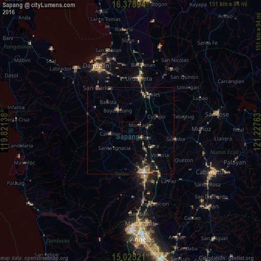
Analysis of Sapang night lights 2016
Square area 10x10 km:
 0%
0%90-99
0%80-89
0%70-79
0%60-69
0.87%50-59
0%40-49
0%30-39
0.87%20-29
0%10-19
0%0-9
98.27%Square area 50x50 km:
0.03%90-99
0.16%80-89
0.38%70-79
0.75%60-69
1%50-59
0.45%40-49
0.83%30-39
1.06%20-29
1.03%10-19
1.98%0-9
92.32%Clear (daylight) street map image can be seen on geolist.org.
Map coordinates:
16° 22' 44.2" North, 119° 49' 17" East
15° 42' 11.5" North, 120° 31' 28.2" East
15° 1' 30.8" North, 121° 13' 39.5" East
Some cities around Sapang sort by population:
• Paniqui
7.1 km =4.4 mi,  122°
122°
• Gerona
13.3 km =8.3 mi,  143°
143°
• Camiling
12.1 km =7.5 mi,  261°
261°
• Burgos
5.9 km =3.7 mi,  60°
60°
• Ramos
13.1 km =8.1 mi,  108°
108°
• Nampicuan
11.2 km =7 mi,  73°
73°
• Baquero Norte
3.5 km =2.2 mi, 65°
• Sinilian First
7.1 km =4.4 mi, 261°
1687302 (p: 11,373)
Sources (retrieved 2019-11-25):
» Earth at Night: Flat Maps 2012, 2016