Pigcawayan night lights from space
Night Light of Pigcawayan (Soccsksargen) from space (Philippines) Src. Average luminocity for 10x10km area is 0.513% and for 50x50km: 1.2823%.
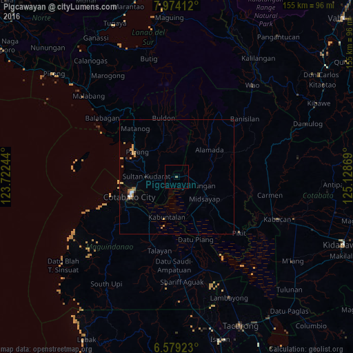
Analysis of Pigcawayan night lights 2016
Square area 10x10 km:
 0%
0%90-99
0%80-89
0%70-79
0%60-69
0%50-59
0.87%40-49
0%30-39
0%20-29
0%10-19
0%0-9
99.13%Square area 50x50 km:
0.09%90-99
0.09%80-89
0.16%70-79
0.48%60-69
0.22%50-59
0.18%40-49
0%30-39
0.15%20-29
0.08%10-19
0.15%0-9
98.42%Clear (daylight) street map image can be seen on geolist.org.
Map coordinates:
7° 58' 26.8" North, 123° 43' 20.8" East
7° 16' 38" North, 124° 25' 32" East
6° 34' 45.2" North, 125° 7' 43.3" East
Some cities around Pigcawayan sort by population:
• Budta
8.3 km =5.2 mi,  169°
169°
• Malingao
14 km =8.7 mi,  157°
157°
• Midsayap
15 km =9.3 mi,  129°
129°
• Pagaluñgan
15.9 km =9.9 mi,  198°
198°
• Dalumangcob
15.4 km =9.6 mi,  244°
244°
• Glad
17.6 km =10.9 mi,  144°
144°
• Libungan
11.2 km =7 mi,  111°
111°
• Buayan
11.6 km =7.2 mi,  98°
98°
1693903 (p: 11,420)
Sources (retrieved 2019-11-25):
» Earth at Night: Flat Maps 2012, 2016