Mangatarem night lights from space
Night Light of Mangatarem (Ilocos) from space (Philippines) Src. Average luminocity for 10x10km area is 1.961% and for 50x50km: 1.4917%.
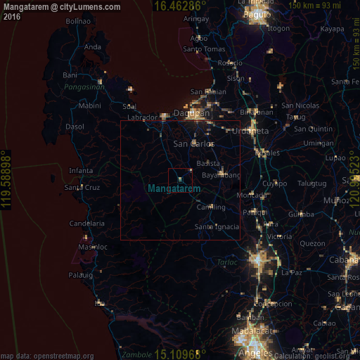
Analysis of Mangatarem night lights 2016
Square area 10x10 km:
 0%
0%90-99
0%80-89
0.43%70-79
0.43%60-69
0.87%50-59
0%40-49
0%30-39
0%20-29
2.16%10-19
0.43%0-9
95.67%Square area 50x50 km:
0%90-99
0%80-89
0.06%70-79
0.26%60-69
0.17%50-59
0.32%40-49
0.44%30-39
0.59%20-29
0.52%10-19
0.93%0-9
96.72%Clear (daylight) street map image can be seen on geolist.org.
Map coordinates:
16° 27' 46.3" North, 119° 35' 20.3" East
15° 47' 14.6" North, 120° 17' 31.6" East
15° 6' 34.8" North, 120° 59' 42.8" East
Some cities around Mangatarem sort by population:
• Camiling
17.1 km =10.6 mi,  130°
130°
• Bayambang
17.7 km =11 mi,  80°
80°
• Urbiztondo
5.6 km =3.5 mi,  45°
45°
• Aguilar
12.6 km =7.8 mi,  332°
332°
• Lepa
20.1 km =12.5 mi,  57°
57°
• Tamayo
10 km =6.2 mi,  355°
355°
• Dumpay
14.8 km =9.2 mi,  44°
44°
• Dorongan Punta
4.5 km =2.8 mi, 47°
1701822 (p: 12,392)
Sources (retrieved 2019-11-25):
» Earth at Night: Flat Maps 2012, 2016