Dumpay night lights from space
Night Light of Dumpay (Ilocos) from space (Philippines) Src. Average luminocity for 10x10km area is 3.3766% and for 50x50km: 5.6053%.
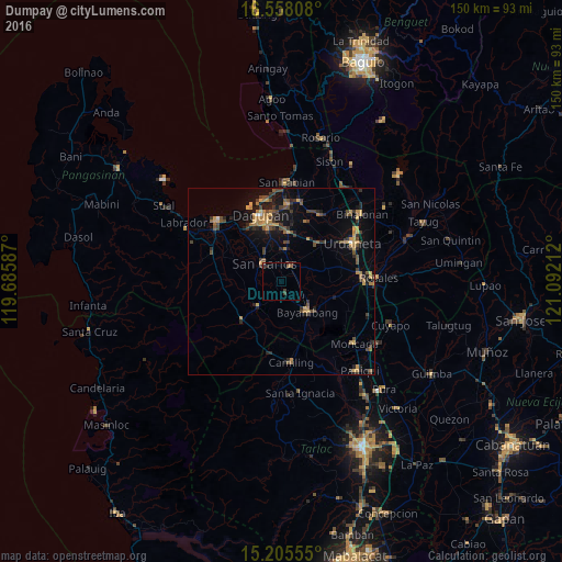
Analysis of Dumpay night lights 2016
Square area 10x10 km:
 0%
0%90-99
0%80-89
0%70-79
0.43%60-69
0.87%50-59
0.87%40-49
0.22%30-39
3.25%20-29
0.87%10-19
0%0-9
93.51%Square area 50x50 km:
0.07%90-99
0.06%80-89
0.51%70-79
1.26%60-69
1.19%50-59
0.66%40-49
1.54%30-39
1.49%20-29
1.29%10-19
3.57%0-9
88.37%Clear (daylight) street map image can be seen on geolist.org.
Map coordinates:
16° 33' 29.1" North, 119° 41' 9.1" East
15° 52' 58.6" North, 120° 23' 20.4" East
15° 12' 20" North, 121° 5' 31.6" East
Some cities around Dumpay sort by population:
• Bayambang
10.6 km =6.6 mi,  137°
137°
• Urbiztondo
9.2 km =5.7 mi,  223°
223°
• Bulog
8.7 km =5.4 mi,  8°
8°
• Lepa
6.6 km =4.1 mi,  88°
88°
• Nagsaing
12.2 km =7.6 mi,  333°
333°
• Loqueb Este
9.2 km =5.7 mi,  41°
41°
• Tamayo
11.2 km =7 mi,  266°
266°
• Dorongan Punta
10.4 km =6.5 mi, 223°
1714106 (p: 5,414)
Sources (retrieved 2019-11-25):
» Earth at Night: Flat Maps 2012, 2016