Lumbangan night lights from space
Night Light of Lumbangan (Calabarzon) from space (Philippines) Src. Average luminocity for 10x10km area is 8.8615% and for 50x50km: 2.8584%.
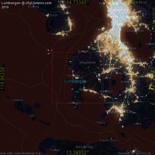
Analysis of Lumbangan night lights 2016
Square area 10x10 km:
 0%
0%90-99
0%80-89
0.22%70-79
4.11%60-69
0.87%50-59
2.38%40-49
2.81%30-39
2.81%20-29
0.65%10-19
0.87%0-9
85.28%Square area 50x50 km:
0.03%90-99
0.03%80-89
0.08%70-79
0.76%60-69
0.48%50-59
0.5%40-49
0.72%30-39
0.68%20-29
0.73%10-19
1.2%0-9
94.78%Clear (daylight) street map image can be seen on geolist.org.
Map coordinates:
14° 44' 0.4" North, 119° 57' 48.9" East
14° 3' 8.6" North, 120° 40' 0.1" East
13° 22' 9.6" North, 121° 22' 11.4" East
Some cities around Lumbangan sort by population:
• Nasugbu
4.1 km =2.5 mi,  293°
293°
• Balayan
14.6 km =9.1 mi,  151°
151°
• General Emilio Aguinaldo
20.2 km =12.6 mi,  43°
43°
• Tuy
7.8 km =4.8 mi,  119°
119°
• Lian
2.8 km =1.7 mi,  222°
222°
• Binubusan
9.8 km =6.1 mi,  199°
199°
• Putol
9.4 km =5.8 mi,  135°
135°
• Aga
15.4 km =9.6 mi,  71°
71°
1705183 (p: 7,071)
Sources (retrieved 2019-11-25):
» Earth at Night: Flat Maps 2012, 2016