Subtanjalla night lights from space
Night Light of Subtanjalla (Ica) from space (Peru) Src. Average luminocity for 10x10km area is 45.4177% and for 50x50km: 6.1889%.
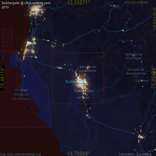
Analysis of Subtanjalla night lights 2016
Square area 10x10 km:
 8.44%
8.44%90-99
10.82%80-89
1.52%70-79
10.39%60-69
4.11%50-59
5.19%40-49
6.06%30-39
5.63%20-29
13.2%10-19
27.92%0-9
6.71%Square area 50x50 km:
0.84%90-99
0.95%80-89
0.44%70-79
1.18%60-69
0.96%50-59
0.63%40-49
0.76%30-39
1.15%20-29
1.81%10-19
4.13%0-9
87.14%Clear (daylight) street map image can be seen on geolist.org.
Map coordinates:
13° 20' 8.6" South, 76° 27' 40.3" West
14° 1' 8" South, 75° 45' 29" West
14° 42' 0.1" South, 75° 3' 17.8" West
Some cities around Subtanjalla sort by population:
• Ica
6.3 km =3.9 mi,  149°
149°
• Chincha Alta
78.9 km =49 mi,  329°
329°
• Pisco
59.2 km =36.8 mi,  305°
305°
• San Clemente
57.7 km =35.9 mi, 312°
• Villa Tupac Amaru
54.4 km =33.8 mi, 308°
• Santiago
19.1 km =11.9 mi,  164°
164°
• Los Aquijes
11.3 km =7 mi,  140°
140°
• San Juan Bautista
2.6 km =1.6 mi,  69°
69°
3928365 (p: 9,096)
Sources (retrieved 2019-11-25):
» Earth at Night: Flat Maps 2012, 2016