Khasab night lights from space
Night Light of Khasab (Musandam) from space (Oman) Src. Average luminocity for 10x10km area is 39.4444% and for 50x50km: 8.1172%.
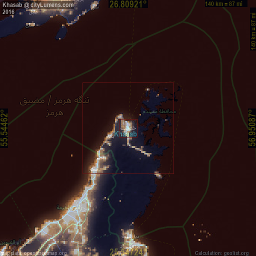
Analysis of Khasab night lights 2016
Square area 10x10 km:
 5.95%
5.95%90-99
6.55%80-89
2.58%70-79
2.58%60-69
11.51%50-59
7.74%40-49
1.39%30-39
6.94%20-29
13.49%10-19
31.94%0-9
9.33%Square area 50x50 km:
0.86%90-99
0.97%80-89
0.8%70-79
0.59%60-69
1.6%50-59
1.95%40-49
0.71%30-39
1.45%20-29
2.15%10-19
7.5%0-9
81.43%Clear (daylight) street map image can be seen on geolist.org.
Map coordinates:
26° 48' 33.2" North, 55° 32' 40.6" East
26° 10' 47.7" North, 56° 14' 51.9" East
25° 32' 50.1" North, 56° 57' 3.1" East
Some cities around Khasab sort by population:
• Bandar Abbas, IR
112 km =69.6 mi,  1°
1°
• Ras Al Khaimah City, AE
53 km =32.9 mi,  215°
215°
• Umm Al Quwain City, AE
97.4 km =60.5 mi,  225°
225°
• Khawr Fakkān, AE
94.8 km =58.9 mi,  174°
174°
• Dibba Al-Fujairah, AE
65.3 km =40.6 mi,  178°
178°
• Dibba Al-Hisn, AE
62.4 km =38.8 mi, 177°
• Qeshm, IR
85.6 km =53.2 mi, 1°
• Adh Dhayd, AE
105.7 km =65.7 mi,  200°
200°
287614 (p: 17,904)
Sources (retrieved 2019-11-25):
» Earth at Night: Flat Maps 2012, 2016