Horten night lights from space
Night Light of Horten (Vestfold) from space (Norway) Src. Average luminocity for 10x10km area is 20.4188% and for 50x50km: 12.4183%.
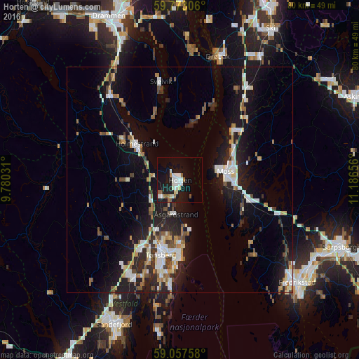
Analysis of Horten night lights 2016
Square area 10x10 km:
 4.11%
4.11%90-99
5.63%80-89
1.52%70-79
0.87%60-69
2.06%50-59
2.27%40-49
0.11%30-39
0.32%20-29
1.52%10-19
30.41%0-9
51.19%Square area 50x50 km:
2.01%90-99
2.41%80-89
0.98%70-79
1.28%60-69
1.34%50-59
1.48%40-49
1.27%30-39
1.04%20-29
3.54%10-19
11.3%0-9
73.34%Clear (daylight) street map image can be seen on geolist.org.
Map coordinates:
59° 46' 23" North, 9° 46' 49.1" East
59° 25' 2" North, 10° 29' 0.3" East
59° 3' 27.3" North, 11° 11' 11.6" East
Some cities around Horten sort by population:
• Fredrikstad
33.6 km =20.9 mi,  131°
131°
• Sandefjord
35.2 km =21.9 mi,  205°
205°
• Tønsberg
17.2 km =10.7 mi,  194°
194°
• Moss
10 km =6.2 mi,  79°
79°
• Drøbak
28.6 km =17.8 mi,  16°
16°
• Ås
32.6 km =20.3 mi,  32°
32°
• Holmestrand
12.2 km =7.6 mi,  309°
309°
• Vestby
25.8 km =16 mi,  35°
35°
3151770 (p: 17,660)
Sources (retrieved 2019-11-25):
» Earth at Night: Flat Maps 2012, 2016