Voorthuizen night lights from space
Night Light of Voorthuizen (Gelderland) from space (Netherlands) Src. Average luminocity for 10x10km area is 16.123% and for 50x50km: 17.6537%.
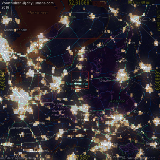
Analysis of Voorthuizen night lights 2016
Square area 10x10 km:
 2.25%
2.25%90-99
2.38%80-89
0.4%70-79
1.85%60-69
1.06%50-59
3.57%40-49
1.72%30-39
0.53%20-29
1.59%10-19
19.84%0-9
64.81%Square area 50x50 km:
2.47%90-99
3.27%80-89
1.99%70-79
2.1%60-69
2.02%50-59
1.58%40-49
1.79%30-39
1.72%20-29
6.49%10-19
16.14%0-9
60.43%Clear (daylight) street map image can be seen on geolist.org.
Map coordinates:
52° 36' 56.4" North, 4° 54' 8.8" East
52° 11' 12" North, 5° 36' 20" East
51° 45' 12.6" North, 6° 18' 31.3" East
Some cities around Voorthuizen sort by population:
• Nijkerk
8.9 km =5.5 mi,  294°
294°
• Leusden
13.3 km =8.3 mi,  243°
243°
• Barneveld
5.4 km =3.4 mi,  195°
195°
• Putten
8.1 km =5 mi,  0°
0°
• Lunteren
11.4 km =7.1 mi,  174°
174°
• Ermelo
12.5 km =7.8 mi,  5°
5°
• Scherpenzeel
14.3 km =8.9 mi,  213°
213°
• Doornsteeg
11.4 km =7.1 mi,  295°
295°
2745271 (p: 9,710)
Sources (retrieved 2019-11-25):
» Earth at Night: Flat Maps 2012, 2016