Scherpenzeel night lights from space
Night Light of Scherpenzeel (Gelderland) from space (Netherlands) Src. Average luminocity for 10x10km area is 17.7963% and for 50x50km: 22.4313%.
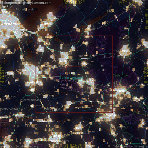
Analysis of Scherpenzeel night lights 2016
Square area 10x10 km:
 1.59%
1.59%90-99
2.65%80-89
1.59%70-79
1.19%60-69
1.32%50-59
2.38%40-49
1.19%30-39
1.98%20-29
3.84%10-19
31.48%0-9
50.79%Square area 50x50 km:
3.05%90-99
3.64%80-89
2.46%70-79
2.44%60-69
2.72%50-59
2.38%40-49
2.59%30-39
3.19%20-29
8.48%10-19
21.41%0-9
47.64%Clear (daylight) street map image can be seen on geolist.org.
Map coordinates:
52° 30' 36.1" North, 4° 47' 8.8" East
52° 4' 48" North, 5° 29' 20" East
51° 38' 44.8" North, 6° 11' 31.3" East
Some cities around Scherpenzeel sort by population:
• Veenendaal
7.5 km =4.7 mi,  140°
140°
• Leusden
7 km =4.3 mi,  326°
326°
• Barneveld
9.3 km =5.8 mi,  44°
44°
• Lunteren
9.1 km =5.7 mi,  86°
86°
• Woudenberg
4.9 km =3 mi,  271°
271°
• Randenbroek
9.7 km =6 mi,  321°
321°
• Leersum
8.7 km =5.4 mi,  208°
208°
• Amerongen
8.8 km =5.5 mi,  193°
193°
2747607 (p: 8,820)
Sources (retrieved 2019-11-25):
» Earth at Night: Flat Maps 2012, 2016