Leersum night lights from space
Night Light of Leersum (Utrecht) from space (Netherlands) Src. Average luminocity for 10x10km area is 4.9798% and for 50x50km: 24.7557%.
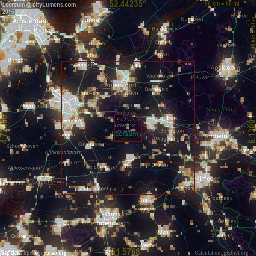
Analysis of Leersum night lights 2016
Square area 10x10 km:
 0%
0%90-99
0%80-89
0%70-79
0.51%60-69
1.26%50-59
0.25%40-49
1.64%30-39
1.14%20-29
0.25%10-19
1.89%0-9
93.06%Square area 50x50 km:
4.53%90-99
4.34%80-89
2.47%70-79
2.22%60-69
2.76%50-59
2.62%40-49
2.63%30-39
2.82%20-29
8.13%10-19
22.79%0-9
44.69%Clear (daylight) street map image can be seen on geolist.org.
Map coordinates:
52° 26' 32.5" North, 4° 43' 28.8" East
52° 0' 42" North, 5° 25' 40" East
51° 34' 36.5" North, 6° 7' 51.3" East
Some cities around Leersum sort by population:
• Veenendaal
9.2 km =5.7 mi,  78°
78°
• Driebergen-Rijsenburg
11.1 km =6.9 mi,  294°
294°
• Rhenen
11.2 km =7 mi,  121°
121°
• Wijk bij Duurstede
7.2 km =4.5 mi,  234°
234°
• Woudenberg
7.7 km =4.8 mi,  354°
354°
• Doorn
6.1 km =3.8 mi, 293°
• Scherpenzeel
8.7 km =5.4 mi,  28°
28°
• Amerongen
2.4 km =1.5 mi, 115°
2751801 (p: 6,385)
Sources (retrieved 2019-11-25):
» Earth at Night: Flat Maps 2012, 2016