Overschie night lights from space
Night Light of Overschie (South Holland) from space (Netherlands) Src. Average luminocity for 10x10km area is 91.5808% and for 50x50km: 52.3068%.
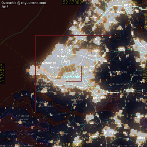
Analysis of Overschie night lights 2016
Square area 10x10 km:
 50.13%
90-99
24.12%80-89
3.66%70-79
7.2%60-69
12.5%50-59
2.4%40-49
0%30-39
0%20-29
0%10-19
0%0-9
0%Square area 50x50 km:
21.54%90-99
13.25%80-89
3.4%70-79
3.67%60-69
4.81%50-59
3.51%40-49
3.41%30-39
5.01%20-29
7.75%10-19
10.2%0-9
23.44%Clear (daylight) street map image can be seen on geolist.org.
Map coordinates:
52° 22' 12.1" North, 3° 43' 28.3" East
51° 56' 19.1" North, 4° 25' 39.6" East
51° 30' 11" North, 5° 7' 50.8" East
Some cities around Overschie sort by population:
• Rotterdam
4 km =2.5 mi,  116°
116°
• Schiedam
3.4 km =2.1 mi,  230°
230°
• Vlaardingen
6.6 km =4.1 mi,  243°
243°
• Schiebroek
3.7 km =2.3 mi,  53°
53°
• Carnisse
6.5 km =4 mi,  148°
148°
• Spangen
2.5 km =1.6 mi,  167°
167°
• Feijenoord
6.2 km =3.9 mi, 119°
• Delfshaven
4.1 km =2.5 mi,  155°
155°
2748826 (p: 6,710)
Sources (retrieved 2019-11-25):
» Earth at Night: Flat Maps 2012, 2016