Matendonk night lights from space
Night Light of Matendonk (Gelderland) from space (Netherlands) Src. Average luminocity for 10x10km area is 40.75% and for 50x50km: 10.5533%.
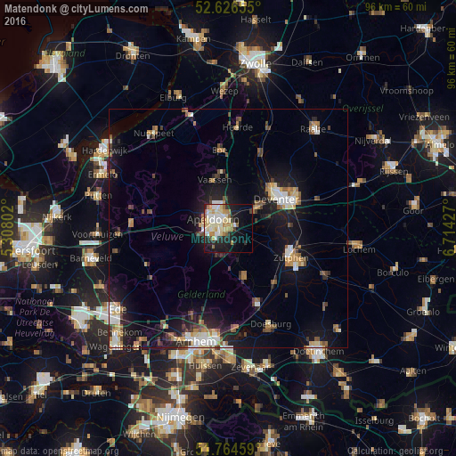
Analysis of Matendonk night lights 2016
Square area 10x10 km:
 6.08%
6.08%90-99
11.51%80-89
7.67%70-79
5.82%60-69
4.89%50-59
3.17%40-49
0.79%30-39
1.85%20-29
10.85%10-19
21.16%0-9
26.19%Square area 50x50 km:
1.28%90-99
1.68%80-89
1.1%70-79
1.09%60-69
1.41%50-59
1.42%40-49
1.28%30-39
1.14%20-29
2.7%10-19
9.53%0-9
77.37%Clear (daylight) street map image can be seen on geolist.org.
Map coordinates:
52° 37' 35.6" North, 5° 18' 28.9" East
52° 11' 51.6" North, 6° 0' 40.1" East
51° 45' 52.5" North, 6° 42' 51.4" East
Some cities around Matendonk sort by population:
• Apeldoorn
3.2 km =2 mi,  295°
295°
• Deventer
12.2 km =7.6 mi,  58°
58°
• Zutphen
14.6 km =9.1 mi,  116°
116°
• Twello
7.6 km =4.7 mi, 55°
• Vaassen
10.3 km =6.4 mi,  342°
342°
• Eerbeek
10.8 km =6.7 mi,  162°
162°
• Orden
5.3 km =3.3 mi,  274°
274°
• Woudhuis
1.7 km =1.1 mi,  0°
0°
6621509 (p: 5,225)
Sources (retrieved 2019-11-25):
» Earth at Night: Flat Maps 2012, 2016