Boekel night lights from space
Night Light of Boekel (North Brabant) from space (Netherlands) Src. Average luminocity for 10x10km area is 16.6965% and for 50x50km: 23.8788%.
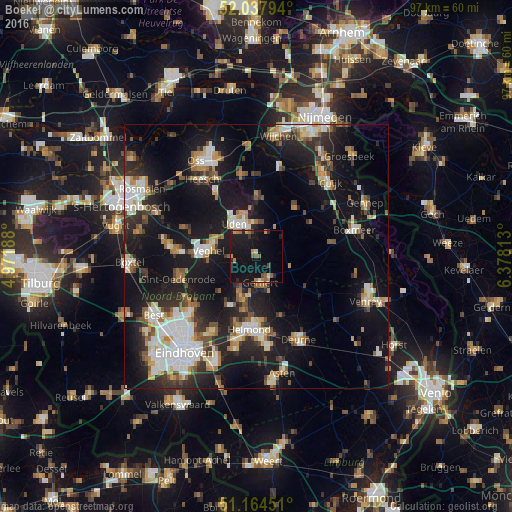
Analysis of Boekel night lights 2016
Square area 10x10 km:
 0%
0%90-99
1.07%80-89
0.8%70-79
2.81%60-69
3.74%50-59
2.81%40-49
1.34%30-39
1.07%20-29
4.14%10-19
36.63%0-9
45.59%Square area 50x50 km:
3.67%90-99
4.4%80-89
2.2%70-79
2.53%60-69
2.9%50-59
3.21%40-49
2.37%30-39
3.27%20-29
6.97%10-19
23.12%0-9
45.38%Clear (daylight) street map image can be seen on geolist.org.
Map coordinates:
52° 2' 16.6" North, 4° 58' 18.8" East
51° 36' 12" North, 5° 40' 30" East
51° 9' 52.2" North, 6° 22' 41.3" East
Some cities around Boekel sort by population:
• Helmond
13.6 km =8.5 mi,  184°
184°
• Uden
7.5 km =4.7 mi,  329°
329°
• Veghel
8.9 km =5.5 mi,  279°
279°
• Gemert
5.4 km =3.4 mi,  168°
168°
• Heeswijk-Dinther
14.8 km =9.2 mi,  290°
290°
• Nistelrode
13.6 km =8.5 mi, 325°
• Beek
8.8 km =5.5 mi,  198°
198°
• Aarle-Rixtel
10.7 km =6.6 mi,  193°
193°
2758759 (p: 5,480)
Sources (retrieved 2019-11-25):
» Earth at Night: Flat Maps 2012, 2016