Blaricum night lights from space
Night Light of Blaricum (North Holland) from space (Netherlands) Src. Average luminocity for 10x10km area is 39.7209% and for 50x50km: 28.5951%.
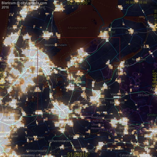
Analysis of Blaricum night lights 2016
Square area 10x10 km:
 3.84%
3.84%90-99
7.54%80-89
2.78%70-79
8.86%60-69
5.03%50-59
3.84%40-49
6.48%30-39
8.6%20-29
18.92%10-19
20.63%0-9
13.49%Square area 50x50 km:
6.61%90-99
5.65%80-89
2.55%70-79
2.65%60-69
2.6%50-59
2.34%40-49
2.81%30-39
3.62%20-29
10.32%10-19
22.51%0-9
38.34%Clear (daylight) street map image can be seen on geolist.org.
Map coordinates:
52° 42' 2.4" North, 4° 32' 18.8" East
52° 16' 21" North, 5° 14' 30" East
51° 50' 24.6" North, 5° 56' 41.3" East
Some cities around Blaricum sort by population:
• Hilversum
7 km =4.3 mi,  219°
219°
• Huizen
3 km =1.9 mi,  0°
0°
• Bussum
5.5 km =3.4 mi,  270°
270°
• Baarn
7.4 km =4.6 mi,  155°
155°
• Naarden
6 km =3.7 mi,  295°
295°
• Laren
2 km =1.2 mi,  208°
208°
• Kortenhoef
9.9 km =6.2 mi,  247°
247°
• Kerkelanden
9.5 km =5.9 mi,  229°
229°
2758868 (p: 5,060)
Sources (retrieved 2019-11-25):
» Earth at Night: Flat Maps 2012, 2016