Bennebroek night lights from space
Night Light of Bennebroek (North Holland) from space (Netherlands) Src. Average luminocity for 10x10km area is 51.7475% and for 50x50km: 36.776%.
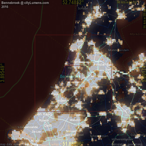
Analysis of Bennebroek night lights 2016
Square area 10x10 km:
 9.34%
9.34%90-99
12.25%80-89
2.65%70-79
5.93%60-69
7.7%50-59
9.6%40-49
13.38%30-39
7.7%20-29
10.98%10-19
14.65%0-9
5.81%Square area 50x50 km:
10.54%90-99
9.19%80-89
2.35%70-79
3.02%60-69
3.84%50-59
3.68%40-49
4.65%30-39
6.39%20-29
10.02%10-19
9.29%0-9
37.03%Clear (daylight) street map image can be seen on geolist.org.
Map coordinates:
52° 44' 54.7" North, 3° 53' 43.8" East
52° 19' 15" North, 4° 35' 55" East
51° 53' 20.3" North, 5° 18' 6.3" East
Some cities around Bennebroek sort by population:
• Haarlem
7.2 km =4.5 mi,  21°
21°
• Hoofddorp
6.5 km =4 mi,  108°
108°
• Heemstede
3.6 km =2.2 mi,  27°
27°
• Lisse
7.3 km =4.5 mi,  202°
202°
• Hillegom
3.5 km =2.2 mi, 197°
• Zandvoort
7.2 km =4.5 mi,  321°
321°
• Sassenheim
11.9 km =7.4 mi,  206°
206°
• Noordwijkerhout
9.7 km =6 mi,  227°
227°
2759199 (p: 5,140)
Sources (retrieved 2019-11-25):
» Earth at Night: Flat Maps 2012, 2016