Bonny night lights from space
Night Light of Bonny (Rivers) from space (Nigeria) Src. Average luminocity for 10x10km area is 63.0207% and for 50x50km: 18.8049%.
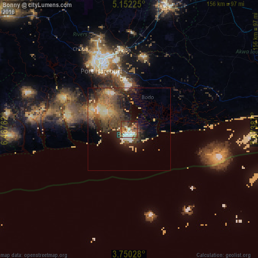
Analysis of Bonny night lights 2016
Square area 10x10 km:
100  14.67%
90-99 12.6%
80-89 3.93%
70-79 7.64%
60-69 9.92%
50-59 16.94%
40-49 13.43%
30-39 9.71%
20-29 6.4%
10-19 4.75%
0-9 0%
14.67%90-99
12.6%80-89
3.93%70-79
7.64%60-69
9.92%50-59
16.94%40-49
13.43%30-39
9.71%20-29
6.4%10-19
4.75%0-9
0%Square area 50x50 km:
100 1.42%
90-99 1.88%
80-89 3.87%
70-79 2.16%
60-69 2.85%
50-59 3.99%
40-49 5.17%
30-39 4.18%
20-29 5.11%
10-19 7.14%
0-9 62.23%
1.42%90-99
1.88%80-89
3.87%70-79
2.16%60-69
2.85%50-59
3.99%40-49
5.17%30-39
4.18%20-29
5.11%10-19
7.14%0-9
62.23%Clear (daylight) street map image can be seen on geolist.org.
Map coordinates:
5° 9' 8.1" North, 6° 28' 3.4" East
4° 27' 5.8" North, 7° 10' 14.7" East
3° 45' 1" North, 7° 52' 25.9" East
Some cities around Bonny sort by population:
• Port Harcourt
40.2 km =25 mi,  334°
334°
• Aba
76 km =47.2 mi,  16°
16°
• Buguma
46.6 km =29 mi,  312°
312°
• Okrika
33.7 km =20.9 mi,  343°
343°
• Obonoma
51.1 km =31.8 mi,  304°
304°
• Elele
82.3 km =51.1 mi, 331°
• Degema Hulk
58 km =36 mi, 306°
• Bori
33 km =20.5 mi,  40°
40°
2346812 (p: 16,868)
Sources (retrieved 2019-11-25):
» Earth at Night: Flat Maps 2012, 2016