Batu Arang night lights from space
Night Light of Batu Arang (Selangor) from space (Malaysia) Src. Average luminocity for 10x10km area is 54.6364% and for 50x50km: 42.4677%.
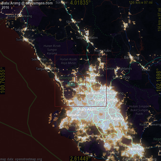

Analysis of Batu Arang night lights 2016
Square area 10x10 km:
 4.11%
4.11%90-99
8.66%80-89
4.33%70-79
11.26%60-69
13.64%50-59
14.94%40-49
6.93%30-39
16.02%20-29
17.97%10-19
2.16%0-9
0%Square area 50x50 km:
14.26%90-99
8.69%80-89
3.23%70-79
4.05%60-69
6.66%50-59
4.85%40-49
3.91%30-39
3.25%20-29
6.63%10-19
13.48%0-9
31%Clear (daylight) street map image can be seen on geolist.org.
Map coordinates:
4° 1' 6.1" North, 100° 45' 48.8" East
3° 19' 0" North, 101° 28' 0" East
2° 36' 52.2" North, 102° 10' 11.3" East
Some cities around Batu Arang sort by population:
• Kampung Baru Subang
20 km =12.4 mi,  158°
158°
• Rawang
12.2 km =7.6 mi,  87°
87°
• Kampong Dungun
20 km =12.4 mi,  236°
236°
• Kuala Selangor
24.3 km =15.1 mi,  278°
278°
• Serendah
16.2 km =10.1 mi,  70°
70°
• Ladang Seri Kundang
6.8 km =4.2 mi,  120°
120°
• Kuang
11.6 km =7.2 mi, 123°
• Batang Berjuntai
9.3 km =5.8 mi,  323°
323°
1732893 (p: 22,579)
Sources (retrieved 2019-11-25):
» Earth at Night: Flat Maps 2012, 2016