Xocotla night lights from space
Night Light of Xocotla (Veracruz) from space (Mexico) Src. Average luminocity for 10x10km area is 1.5736% and for 50x50km: 14.7283%.
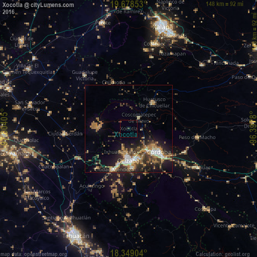
Analysis of Xocotla night lights 2016
Square area 10x10 km:
 0%
0%90-99
0%80-89
0%70-79
0%60-69
0.87%50-59
0%40-49
0.87%30-39
0%20-29
0%10-19
0%0-9
98.27%Square area 50x50 km:
1.24%90-99
1.93%80-89
1.62%70-79
2.25%60-69
3.61%50-59
1.48%40-49
2.82%30-39
3.31%20-29
4.22%10-19
7.27%0-9
70.25%Clear (daylight) street map image can be seen on geolist.org.
Map coordinates:
19° 40' 42.7" North, 97° 48' 14.6" West
19° 0' 54.4" North, 97° 6' 3.3" West
18° 20' 56.5" North, 96° 23' 52.1" West
Some cities around Xocotla sort by population:
• Fortín de las Flores
15.9 km =9.9 mi,  138°
138°
• Coscomatepec de Bravo
8.6 km =5.3 mi,  41°
41°
• Palmira
14.8 km =9.2 mi,  184°
184°
• Chocamán
7.2 km =4.5 mi,  92°
92°
• Atzacan
12.1 km =7.5 mi,  171°
171°
• Unión y Progreso
15.9 km =9.9 mi,  186°
186°
• Monte Blanco
10.4 km =6.5 mi,  121°
121°
• Ixhuatlán del Café
12.9 km =8 mi,  71°
71°
3514424 (p: 7,168)
Sources (retrieved 2019-11-25):
» Earth at Night: Flat Maps 2012, 2016