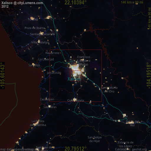
Xalisco night lights from space
Night Light of Xalisco (Nayarit) from space (Mexico) Src. Average luminocity for 10x10km area is 45.7254% and for 50x50km: 6.4567%.

Analysis of Xalisco night lights 2016
Square area 10x10 km:
 8.71%
8.71%90-99
10.8%80-89
9.28%70-79
4.73%60-69
2.84%50-59
2.65%40-49
4.92%30-39
7.01%20-29
13.83%10-19
23.86%0-9
11.36%Square area 50x50 km:
0.73%90-99
0.99%80-89
1.36%70-79
0.81%60-69
0.56%50-59
0.52%40-49
1.24%30-39
1.08%20-29
1.8%10-19
3.99%0-9
86.93%Clear (daylight) street map image can be seen on geolist.org.
Map coordinates:
22° 6' 14.2" North, 105° 36' 5.1" West
21° 27' 3.6" North, 104° 53' 53.9" West
20° 47' 42.4" North, 104° 11' 42.6" West
Some cities around Xalisco sort by population:
• Tepic
6.5 km =4 mi,  2°
2°
• Santiago Ixcuintla
51.5 km =32 mi,  321°
321°
• Compostela
23.7 km =14.7 mi,  180°
180°
• Las Varas
38.9 km =24.2 mi,  219°
219°
• San Blas
41.4 km =25.7 mi,  284°
284°
• Villa Hidalgo
47.2 km =29.3 mi,  313°
313°
• Francisco I. Madero
16.7 km =10.4 mi,  29°
29°
• Puga
16.7 km =10.4 mi, 27°
4004159 (p: 35,702)
Sources (retrieved 2019-11-25):
» Earth at Night: Flat Maps 2012, 2016