Tacoaleche night lights from space
Night Light of Tacoaleche (Zacatecas) from space (Mexico) Src. Average luminocity for 10x10km area is 12.875% and for 50x50km: 8.9731%.
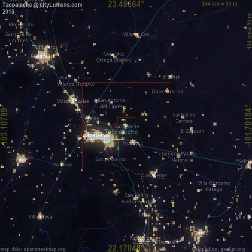
Analysis of Tacoaleche night lights 2016
Square area 10x10 km:
 0%
0%90-99
0.79%80-89
4.17%70-79
2.18%60-69
0.99%50-59
1.39%40-49
0.99%30-39
0.99%20-29
0.6%10-19
11.11%0-9
76.79%Square area 50x50 km:
0.99%90-99
1.24%80-89
1.54%70-79
1.54%60-69
0.97%50-59
0.67%40-49
1.16%30-39
1.22%20-29
2.8%10-19
5.62%0-9
82.27%Clear (daylight) street map image can be seen on geolist.org.
Map coordinates:
23° 27' 59.9" North, 103° 6' 28.4" West
22° 49' 12.4" North, 102° 24' 17.1" West
22° 10' 13.7" North, 101° 42' 5.9" West
Some cities around Tacoaleche sort by population:
• Zacatecas
19 km =11.8 mi,  252°
252°
• Guadalupe
14.2 km =8.8 mi,  235°
235°
• Víctor Rosales
33.7 km =20.9 mi,  295°
295°
• Trancoso
10.2 km =6.3 mi,  157°
157°
• Morelos
21.6 km =13.4 mi,  282°
282°
• Dulce Grande
31.1 km =19.3 mi,  49°
49°
• Los Zacatones
39.1 km =24.3 mi,  66°
66°
• Pozos de Gamboa
22.2 km =13.8 mi,  310°
310°
3982668 (p: 8,612)
Sources (retrieved 2019-11-25):
» Earth at Night: Flat Maps 2012, 2016