Tlacotepec night lights from space
Night Light of Tlacotepec (Morelos) from space (Mexico) Src. Average luminocity for 10x10km area is 18.816% and for 50x50km: 20.0787%.
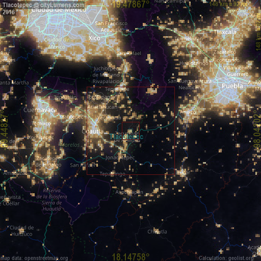
Analysis of Tlacotepec night lights 2016
Square area 10x10 km:
 0%
0%90-99
0.22%80-89
1.73%70-79
3.03%60-69
7.14%50-59
1.08%40-49
3.68%30-39
2.16%20-29
3.46%10-19
17.32%0-9
60.17%Square area 50x50 km:
0.61%90-99
1.25%80-89
3.53%70-79
3.75%60-69
4.89%50-59
2.52%40-49
4.3%30-39
3.84%20-29
4.77%10-19
14.15%0-9
56.41%Clear (daylight) street map image can be seen on geolist.org.
Map coordinates:
19° 28' 43.2" North, 99° 26' 53.8" West
18° 48' 52" North, 98° 44' 42.5" West
18° 8' 51.3" North, 98° 2' 31.3" West
Some cities around Tlacotepec sort by population:
• Yecapixtla
14.8 km =9.2 mi,  301°
301°
• Juan Morales
18.6 km =11.6 mi,  268°
268°
• Tetela del Volcán
8.9 km =5.5 mi,  10°
10°
• Jonacatepec
16.1 km =10 mi,  202°
202°
• Ecatzingo de Hidalgo
15.7 km =9.8 mi,  357°
357°
• Hueyapan
10.7 km =6.6 mi,  38°
38°
• Temoac
5.8 km =3.6 mi,  215°
215°
• Amayuca
11.5 km =7.1 mi,  209°
209°
3515475 (p: 5,087)
Sources (retrieved 2019-11-25):
» Earth at Night: Flat Maps 2012, 2016