Hueyapan night lights from space
Night Light of Hueyapan (Morelos) from space (Mexico) Src. Average luminocity for 10x10km area is 11.1537% and for 50x50km: 18.4301%.
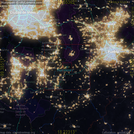
Analysis of Hueyapan night lights 2016
Square area 10x10 km:
 0%
0%90-99
0%80-89
0%70-79
0%60-69
5.19%50-59
1.3%40-49
3.03%30-39
3.9%20-29
3.03%10-19
5.19%0-9
78.35%Square area 50x50 km:
0.23%90-99
0.58%80-89
3.14%70-79
3.01%60-69
4.64%50-59
2.21%40-49
3.85%30-39
3.25%20-29
5.89%10-19
18.18%0-9
55.03%Clear (daylight) street map image can be seen on geolist.org.
Map coordinates:
19° 33' 13" North, 99° 23' 6.5" West
18° 53' 22.9" North, 98° 40' 55.2" West
18° 13' 23.3" North, 97° 58' 44" West
Some cities around Hueyapan sort by population:
• Yecapixtla
19.3 km =12 mi,  267°
267°
• Ozumba de Alzate
20.2 km =12.6 mi,  323°
323°
• Atlautla
17.9 km =11.1 mi,  325°
325°
• Tetela del Volcán
5 km =3.1 mi, 274°
• Ecatzingo de Hidalgo
10.3 km =6.4 mi,  314°
314°
• San Jerónimo Coyula
17.4 km =10.8 mi,  88°
88°
• Temoac
16.5 km =10.3 mi,  217°
217°
• Tlacotepec
10.7 km =6.6 mi, 218°
3526934 (p: 6,478)
Sources (retrieved 2019-11-25):
» Earth at Night: Flat Maps 2012, 2016