Bosque de Saloya night lights from space
Night Light of Bosque de Saloya (Tabasco) from space (Mexico) Src. Average luminocity for 10x10km area is 87.3139% and for 50x50km: 40.3627%.
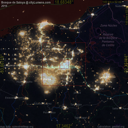
Analysis of Bosque de Saloya night lights 2016
Square area 10x10 km:
 38.96%
90-99
28.79%80-89
11.04%70-79
2.16%60-69
2.6%50-59
7.79%40-49
4.33%30-39
4.33%20-29
0%10-19
0%0-9
0%Square area 50x50 km:
4.16%90-99
7.93%80-89
8.62%70-79
3.35%60-69
5.67%50-59
6.32%40-49
7.33%30-39
8.94%20-29
12.08%10-19
12.99%0-9
22.61%Clear (daylight) street map image can be seen on geolist.org.
Map coordinates:
18° 41' 0.5" North, 93° 39' 40.3" West
18° 0' 58" North, 92° 57' 29" West
17° 20' 46.3" North, 92° 15' 17.8" West
Some cities around Bosque de Saloya sort by population:
• Villahermosa
4.4 km =2.7 mi,  137°
137°
• Pomoca
4.7 km =2.9 mi,  37°
37°
• Parilla
12 km =7.5 mi,  158°
158°
• La Selva
1 km =0.6 mi,  326°
326°
• Río Viejo Primera Sección
8.9 km =5.5 mi,  195°
195°
• Huapinol
11.5 km =7.1 mi,  154°
154°
• La Lima
12 km =7.5 mi,  167°
167°
• Anacleto Canabal 2da. Sección
8.3 km =5.2 mi,  237°
237°
8858176 (p: 8,600)
Sources (retrieved 2019-11-25):
» Earth at Night: Flat Maps 2012, 2016